The Most Mysterious Geoglyphs On The Planet
First, let’s start with the details: what is a geoglyph, anyway?
World Atlas says it’s a pretty open-ended definition, and it’s basically a design that someone’s made on the surface of the earth. There are two different kinds: a negative geoglyph is when the ground or rock is etched away to make an imprint, and a positive geoglyph is when elements — like rocks or gravel — are carefully piled up to make the design. They’re usually more than 13 feet in length, and some are much, much bigger than that.
Some, in fact, are downright huge and cover an almost unthinkable area. Some, we walked right past and didn’t know they were there until we took to the air (and invented Google Earth), and that’s pretty weird. Officially, geoglyphs are art — they’re usually said to serve no other purpose, but some are so big and so mysterious that who are we to judge? It’s entirely possible that some of the world’s intricate geoglyphs served a purpose well beyond art, and it’s possible, well … it’s possible that some were just done for a laugh.
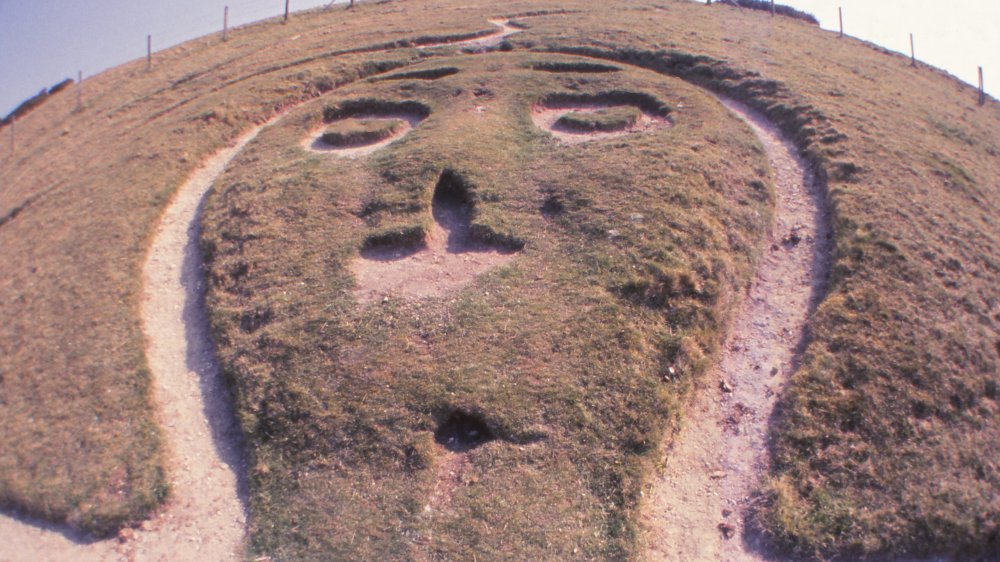
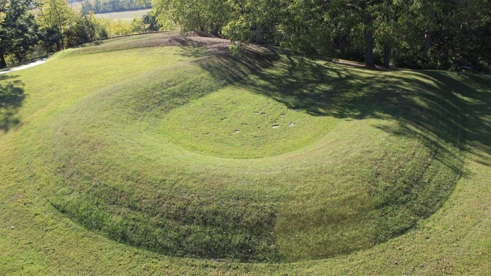
Whatever this geoglyph is, it's probably not an alligator
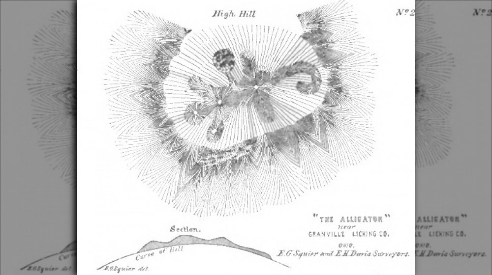
It’s officially called the Alligator Effigy Mound, but it’s safe to say that it’s not actually representing an alligator. Unfortunately, what it is has long been lost, and here’s why.
The Alligator Effigy Mound, Ohio History Central explains, is located in Granville, Ohio, not far from the remnants of a settlement built by the Hopewell. For a long time, the two were connected. Touring Ohio says it’s only fairly recently that the Alligator Mound has been dated to around the year 1300, which puts its creation at the time of another group of Native people called the Fort Ancient Culture, who were descendants of the Hopewell.
And here’s where things get tricky. By the time European settlers moved into the area, the original builders were long gone — and they took their secrets with them. The Native inhabitants those settlers asked didn’t know what it was, either, and when they offered their thoughts, something got lost in translation. They suggested it was a dangerous underwater creature, and settlers immediately thought, “alligator.” But there’s another option: they could have been talking about a creature called the Underwater Panther.
That, History Collection says, was also called the Mishibizhiw, and it was a legendary creature who lived in the region’s lakes and rivers and drowned those who weren’t paying attention to the potential deadly powers of the water. Is that the creature really depicted on the Alligator Effigy Mound? We’ll likely never know for sure.
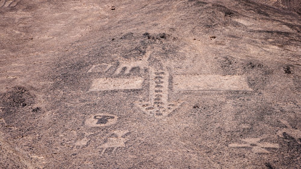
This geoglyph is a weapon of a god… or a tribute to a fun time?
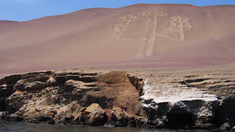
The Paracas Candelabra is a massive geoglyph on a sandy hillside overlooking the Pacific Ocean. It’s one of Peru’s many geoglyphs, and even though it’s been given the moniker of “candelabra,” that’s certainly not what it was originally meant to be.
Atlas Obscura says the ancient geoglyph has been dated to around the year 200 BCE, and from the tip of the center “candle” to the bottom of the “handle,” it’s around 600 feet long. It’s a negative geoglyph — which means it’s dug out of the hillside, and it’s about 2 feet at the deepest.
And … that’s literally all we really know. Historians aren’t sure who made it, or what it’s supposed to be for, but they have some seriously fascinating guesses. One suggests it’s supposed to represent the weapon of choice of the Incan god Viracocha: a trident. That makes perfect sense, but it’s not the only guess. Another theory says that it was dug into the oceanfront hillside as a signal to sailors who might be looking for that part of the coastline.
That also sounds pretty legit, but it’s the last theory that might cause the warm and fuzzy feeling of the knowledge that no matter when and where people are born, they’re still people. It’s also been suggested it’s a massive tribute to the Jimson weed, a plant known — and occasionally loved — for its hallucinogenic properties.
Wait a second, who put that geoglyph there?
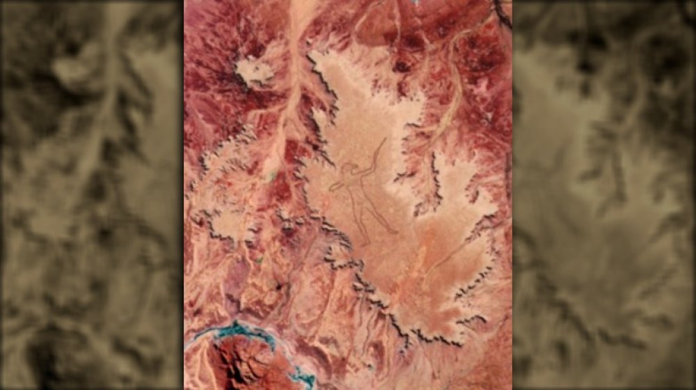
Australia’s Marree Man was first spotted by a pilot flying over Australia in 1998, and when he got back to town, he asked the locals, “Hey, what’s that figure of a man carved into the earth?” They all thought he’d been at the Jimson weed. “They thought I was a little bit mad at the time,” Trec Smith later told ABC. “I tried to explain to them this thing is huge. I could see it from 6,000 feet.”
“Huge” is an understatement: it’s more than 2.5 miles long and spans more than 17 miles. And somehow, no one has the foggiest idea who made it, although there’s been plenty of clues.
A few weeks later, faxes were sent to the media claiming that no laws had been broken and that it was hoped the Marree Man would be used to raise money for both local governments and local Aboriginal peoples. It also directed authorities to look for a plague near the figure’s nose — which was found, along with an American flag, and a note that made reference to the Branch Davidians cult.
The figure — which News.com.au says seems to have been inspired by an ancient statue of Zeus — originally upset the Aboriginal Arabana people who owned the land that was used. By the time it was restored in 2016, opinions were mixed, the BBC says, and there’s still a reward out there for information on who was behind it.
“The gold is not metal. It is our knowledge.”
High Country News calls Alfredo Acosta Figueroa “the geoglyph guardian,” and that’s apt. For years, he’s been fighting to protect the geoglyphs of the American southwest, and even though he might have some non-traditional ideas about who made them and why, his attempts at preserving them are legit … if not tricky.
Figueroa still lives near his hometown of Blythe, California, which also happens to be the home of the Blythe Intaglios, a series of geoglyphs that include three groups of six figures each, including animals and people, that have been dated to anywhere from 450 and 2,000 years old. According to the Bureau of Land Management, the human figures represent the Creator and the animals are those who aided in creation — which makes it ironic that they’re now under threat.
The problem is energy: that area has become targeted for the installation of solar panels and arrays. While solar energy is something most people might get on board with, it’s the potential destruction of these ancient geoglyphs that’s the problem. And one of the Blythe Intaglios has already been damaged, during a road-widening project.
There’s a lot that’s still unknown about the geoglyphs. Figueroa thinks they’re connected to a long-lost Aztec homeland in the southwestern US, a theory that’s pretty far from mainstream. Other tribes have other ideas (the Mojave simply say they have always been there), but they’re united by the idea that they have to be saved.
A long-lasting geoglyph tribute to one of our oldest companions
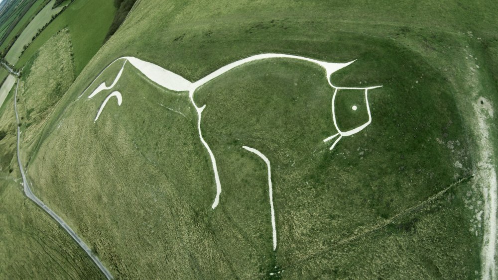
According to the Archaeological Institute of America, people have been writing about Uffington’s White Horse for a long time: it shows up in multiple medieval texts, and one popular legend claimed that it was carved in 875 to celebrate an Anglo-Saxon army driving back Viking invaders. But in the 1990s, excavations found that in 875, the horse was already old enough to be considered ancient.
It dates to somewhere between 1380 and 550 BCE, and there’s a fascinating theory that’s been developed recently. Researchers from the University of Southampton observed the horse from the opposite hill and found that in midwinter, it’s positioned so the sun rises behind the horse and passes over it throughout the day. That’s led them to suspect it’s a depiction of one of the ancient “solar horses,” thought to pull the sun across the sky in a celestial chariot.
That’s the theory, at least, and one thing that’s not a theory is that the horse has held a special place in the hearts of locals for a long, long time. If it were to go unattended, it’s estimated that it would be overgrown and completely obscured in about 20 years. But instead, the Smithsonian says that for the past 3,000 years, locals have regularly gathered to rechalk the horse and make sure it continues to gallop with the sun.
The most famous geoglyphs of all
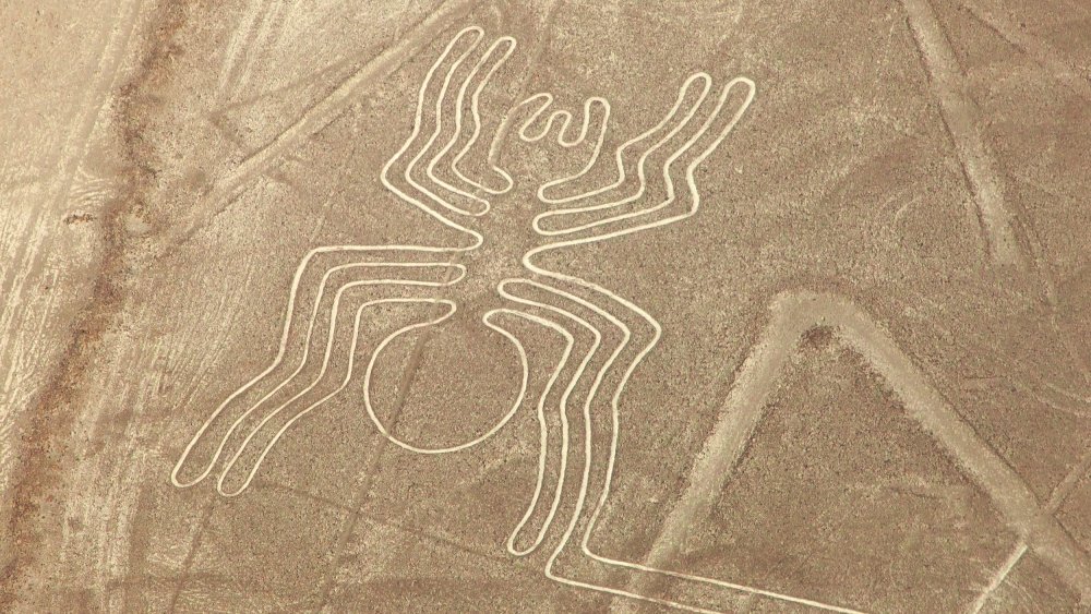
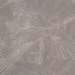
The most famous geoglyphs are probably Peru’s Nazca lines. According to National Geographic, they’ve been the subject of study, speculation, and mystery since they were first studied in 1926. They’re mind-boggling huge: there’s more than 800 straight lines, 70 figures of plants and animals, and 300 geometric shapes. Some are larger than the Empire State Building, and that means they’re impossible to see from the ground.
So, what do we know? For starters, we haven’t found them all. In October 2020, news broke (via The Guardian) that archaeologists had found another figure, this one of a 121-foot-long cat, etched into a hillside and almost completely obscured because of erosion that had been chipping away at it. It was dated to between 500 BCE and 200, based on the style of the figure, and that’s a little outside the norm: Nat Geo says most researchers believe the lines were made by the Nasca people, between 1 and 700.
And that’s about all we know. For a long time, it was believed that the lines related to the movements of the stars and, in turn, to the clock, the calendar, and the seasons. By the 1970s, though, new theories were being developed. That includes the suggestion that they’re actually pointing to (or part of) ritual sites, many of which were used to appeal to the gods for rain or crop fertility. Were they? Who knows!
Of course there's a NSFW geoglyph
He’s called the Cerne Abbas Giant, and he’s etched into the English countryside in Dorset. And he’s … well, he’s very happy about it.
According to the BBC, the negative geoglyph stands 180 feet tall, and no one’s entirely sure what the point of him is supposed to be, although there’s definitely some ideas. The obvious one is that he was a nod to ancient pagan fertility deities, but not everyone agrees.
It’s also been suggested the club-wielding figure might be an ancient deity called Helis, or even a depiction of Hercules. Still, others say that he popped up on the hillside during the English Civil War and that he was a parody of Oliver Cromwell. If that’s the case, no one should have any doubts about what the designer thought about Cromwell.
Figuring out just who or what the Cerne Abbas Giant is supposed to be has only gotten more complicated. In the 1980s, a survey suggested there were original elements that were no longer visible, including a cloak and a head at the figure’s feet. And, in 2020, tests ordered by the National Trust found (via the BBC) that the figure likely dates to the 13th or 14th century … which unfortunately rules out the Cromwell theory.
A desert filled with geoglyph artwork
The sheer scale of the geoglyphs scattered across the Atacama Desert is mind-boggling. According to ThoughtCo., more than 5,000 geoglyphs have been discovered, sprawling over a section of Chilean desert that’s a shocking 60,000 square miles. While many are relatively simple geometric shapes like circles, arrows, and the stepped rhombus, there’s also a ton of animals. One of the most common is the llama, and some geoglyphs feature a line of as many as 80 llamas in a row. There’s also monkeys, dolphins, eagles, lizards, and serpents, along with human figures depicted doing things like hunting and fishing.
Like most of the world’s geoglyphs, we have no idea what these massive works of art mean, but there’s plenty of suggestions. Some think that given the number of geoglyphs that seem to depict llama caravans, some may have essentially acted as signposts to guide travelers through the harsh desert and point out things like salt flats and water sources. (And “harsh” is putting it mildly, as LiveScience says, the Atacama Desert averages less than a millimeter of rain per year.) Others think they’re ritual sites, or that they might be connected to astronomical alignments.
Some of the geoglyphs are gathered in areas, like Chug-Chug. The World Monuments Fund says Chug-Chug is home to 23 sites and 500 geoglyphs, most made between 900 and 1550. A few have been dated to 1000 BCE, which makes it all that much more difficult to interpret.
The mystery of the largest letters in the world
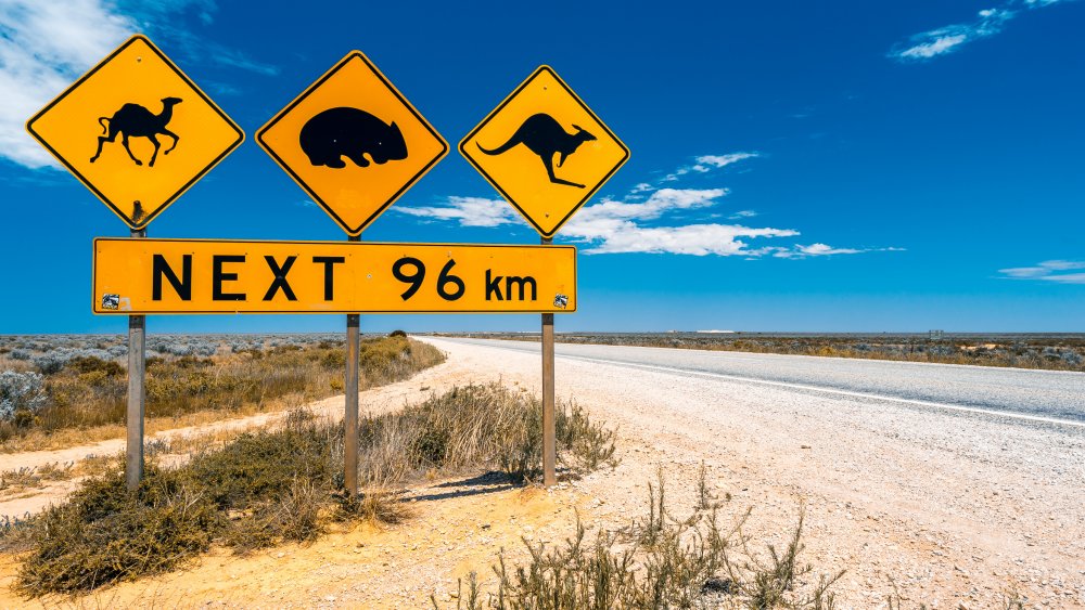
So here’s a weird story: some of the largest letters in the world are carved into Australia’s Nullarbor Plain. They simply say “READY MIX,” and they’re surrounded by a diamond that finishes off the company’s logo. Each letter is 800 feet tall and 600 feet wide, and the whole thing is about 2 miles long and a mile high. Readymix, per Atlas Obscura, was the company contracted to oversee the quarrying that needed to be done to fix the Eyre Highway during a massive road construction project in the 1960s, but no one knows how the heck their logo ended up carved into the landscape.
Hilariously, we do know that a man named Allan Hoare was told to get to work over a holiday weekend and carve the logo into the plain. Just why? That’s a little less clear because Readymix absolutely didn’t have permission to deface the landscape. If they intended for it to be an advertising stunt, they didn’t want to admit to it.
They ultimately claimed it was part of an airstrip, but the problem is that it was never actually used or recorded as being an airstrip, so the actual story behind just why Hoare was tasked with this massive undertaking — and on a holiday weekend, no less — has been long lost. Permission to re-etch the logo was revoked in 1980, and it’s now faded.
Someone was practicing their lines with geoglyphs
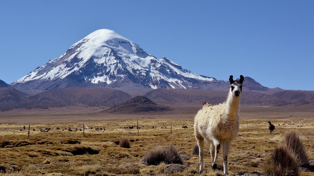
Criss-crossing the Bolivian desert are lines — lots and lots of lines. According to Bolivian Life, they cover an area near the Sajama volcano that’s nearly 9,000 square miles, and the longest of the lines are an impressive 12 miles from start to finish. And here’s the thing — even though the Sajama Lines stretch an insane distance over uneven, rocky terrain, each of the thousands of lines is perfectly straight.
Amusing Planet says that from the ground, you’d never know they were there. It’s only from the air that researchers realized the sheer number of lines, which often start at the same point and radiate outwards. It’s been speculated that those origin points might indicate ancient settlements, sacred sites, or burial places, but no one’s sure what’s going on here.
And sadly, the lines haven’t gotten the same kind of attention as other geoglyphs. There was one — and only one — scientific study mounted by the University of Pennsylvania in 2003, but otherwise, it seems low on archaeology’s to-do list.
The geoglyphs along the landscape of Kazakhstan
It’s amazing to think about the surprises hiding in plain view, and in 2014, researchers from Kostanay University and Vilnius University started examining geoglyphs that were only discovered with help from Google Earth. According to LiveScience, there are more than 50 geoglyphs decorating the landscape of northern Kazakhstan, including a plethora of geometric shapes. Among the rings, crosses, and squares, there’s also a swastika — which, it’s important to note — is an ancient design that IFLScience explains has been used for more than 3,000 years, usually to symbolize good luck and prosperity, until the Nazis went ahead and ruined it.
The individual geoglyphs are around 300 feet in diameter on the small side, all the way up to 1300 feet on the larger side. For comparison, that’s a few hundred feet bigger than the Eiffel Tower.
Investigations into the geoglyphs have yielded some fascinating insights: they’re around 2,800 years old, which puts them right around the time that iron was replacing bronze. The purpose of the geoglyphs still isn’t clear, but it’s been suggested they may have been used as territory markers. Some show signs of habitation and the presence of hearths and other structures have led researchers to think they may have served as some sort of sanctuary in the middle of the steppe.
A giant snake geoglyph? Oh, my!
There’s a snake slithering along a hilltop in southern Ohio, and no one’s entirely sure how long it’s been there, why it was made, or what it’s supposed to mean. We do know, Cleveland says, that it’s the longest snake effigy in the world, and it stretches for a whopping 1,348 feet.
First, what else do we know? Not much. It’s been dated to around 1070 and the Fort Ancient Culture. However, SmartHistory says even that’s just the “leading theory,” as it’s entirely possible that the mound as it exists today was a refurbishment of a much older mound. We also know that it’s not a burial ground, although there are burial mounds in the area.
There’s been a lot of theories put forward on just what the massive serpent is. Some suggest it was plucked out of the night sky, perhaps representing a constellation or an astronomical event like a comet or a supernova. It may have been used as a compass, or to mark the changing seasons, or it may have been consulted to figure out when crops needed to be planted or harvested. And that makes sense: the head of the snake points toward the summer solstice, and the tail to the winter. Even the shape of the snake’s head has been hotly debated, with some suggesting it’s an egg, an eye, and even a frog being swallowed by the snake.
Two Objects In Our Solar System That Orbit The Sun Backwards

Deadliest Poisons In The World

This Might Be The Strangest Gameshow That Japan Has Ever Made

The Truth Behind The Exorcism Of Roland Doe, Inspiration For The Exorcist

Creepy Tales Of The Shipwrecks In The Great Lakes

The Truth About Ranked-Choice Voting

The Real Reason UPS Trucks Have White Roofs

The Real Reason Doomsday Preppers Stockpile So Many Condoms

Regular People Who Became Famous For All The Wrong Reasons

U.S. Presidents Who Were Really Weird People